Suggested bird walks and drives around Mallacoota for Birders Big Weekend 11 – 14 March 2022
by Martin Butterfield, with Janine Duffy

In the Key Maps above & below, the locations with an individual walk map are shown with a red number on a yellow background (Walks). A few other points shown with a blue number on a green background indicate spots at which a stationary checklist might be considered (Drive & stop).

Drive & stop 1: Captain Stevensons Point
-37.5590 149.7628
eBird Hotspot: Captain Stevensons Point https://ebird.org/hotspot/L2552541
Best conditions: high tide.
Pretty much in centre of town.
Accessibility: Walk from bitumen across smooth grass. Beware of steep drop to waterline! At Point B trees restrict view unless go down steps to water level
Distance: 100 m
Bird notes: explore Hotspot in Ebird for full list of 129 species. At least one visit here essential. If mouth open best to visit near high tide which concentrates
From point A excellent views over mouth of Inlet and ocean out towards Gabo Island. A telescope helps!! Just about any wader or waterbird or seabird possible.
From point B look up Develings Inlet for herons and other marsh birds as well as some sandbars not visible from point A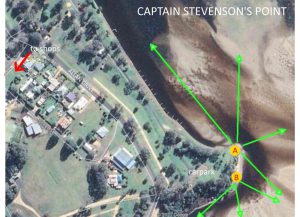
……..
Walk 1: The Narrows
-37.5295 149.7398
eBird Hotspot: The Narrows https://ebird.org/hotspot/L3961469
Best conditions: early morning
Follow signs to Bucklands Boat Hire along Lakeside Drive. Pass boat hire and park in turning circle.
Accessibility: the track is flat but rather rocky in places. Not suitable for wheelchairs.
Distance: 2.3 kms one way, but go as far as you like then return.
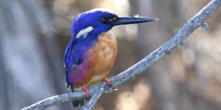
Bird notes: This is one of the most accessible ‘remote’ sites close to town. Some special birds have been seen here, probably because its the most narrow point of the inlet, and a safe crossing place: Beautiful Firetail, Cicadabird, and Topknot Pigeon. There’s some nice rainforest at the 2nd gully, point A. Check Sweet Pittosporums in parking area for Nankeen Night Heron. Check farm dam for ducks and other water birds. General bush birds along track including Eastern Spinebill, lorikeets, Brown & Striated Thornbill, Black-faced Monarch and Rose Robin. Check shoreline trees for Azure Kingfisher, cormorants & herons. White-bellied Sea-Eagles and Whistling Kite fly along the water.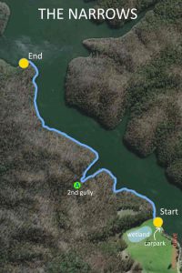
……….
Walk 2: Bucklands to Mullet Ck
-37.5295 149.7398
eBird Hotspot: Karbeethong https://ebird.org/hotspot/L3129891
Best conditions: anytime
Follow signs to Bucklands Boat Hire on Lakeside Drive. Pass boat hire and park in turning circle.
Accessibility: the track is flat. Some smooth gravel to begin with. OK for wheelchairs. On road walking for first 500m: be aware of traffic on bends. At Mullet Creek do not go beyond gate or out of cleared area into private property.
Distance: 1.5 kms one way.
Bird notes: As for walk above at start. The walk covers a wide range of habitats and 30+ species usually noted from path. Forest species (Black-faced Monarch; Rufous Fantail) and Grey Goshawk possible at Mullet Creek. Check shoreline trees and jetties for Azure Kingfisher and Pied Cormorants. White-bellied Sea-Eagles, pelicans and Whistling Kite often seen overhead.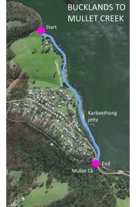
………
Walk 3: Stingray Point
-37.5423 149.7568
eBird Hotspot: Stingray Point https://ebird.org/hotspot/L12263809
Park on verge on LHS of Angophora Dr. The walk follows the path behind the houses and returns along the shared path on Lakeside Drive. Please respect the privacy of houses in the first 300m.
Accessibility: the track is quite steep on both ends of the inland loop. Be wary of traffic when crossing Lakeside Dr,
Distance: 1.3 kms loop
Bird notes: The large Angophoras at point X are often good for unusual species, as are the two fig trees nearby (when they have fruit). The vegetation downhill of the path is dense so can be interesting. Keep an eye open for Azure Kingfisher on Lakeside Drive. It might be worth looking in the patch of forest on the corner of Angophora Drive.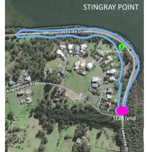
……..
Walk 4: Coull’s Inlet
-37.5549 149.7567-37.569
eBird Hotspot: Coulls Inlet https://ebird.org/hotspot/L3498172 can be used to record the whole walk. Some people record birds seen on the Broome St Lagoon (point E) as a separate list: Inlet and Gully off Lakeside Dr at Broome St, Mallacoota https://ebird.org/hotspot/L7057573
Best conditions: good in morning and evening
Parking is easiest at the Main Wharf, ensuring that access for vehicles launching boats is maintained. Some parking may be available at Fisheries Jetty (point F) if you wish to do a car shuffle.
Accessibility: Flat, shared path. Wheelchair accessible
Distance: 2.3 kms one way
Bird notes:
Point A – the path is opposite Shady Gully and a range of forest birds can be observed in there (dominated by the calls of Bell Miners)
Point B – from the new boardwalk scan the shoreline and mud flats for ducks and waders. In cooler months Hoary-headed Grebes feed in the Inlet.
Point C – Check the jetties to see what is resting. Can be good for Azure Kingfisher.
Point D – Check out the small island opposite. Usually a lot of gulls and pelicans but sometimes Royal Spoonbill join them and various other waders. Swamp and Spotted Harrier may patrol the area (both rate as unusual).
Point E – Check shoreline of lagoon for ducks, herons & egrets etc. A favoured roost area for Royal Spoonbills (check carefully for Yellow-billed Spoonbill, now very unusual in the area) and Australian White Ibis. A side walk along Lakeside Drive here in early morning or late evening may turn up a White-headed Pigeon or two.
Point F – Fisheries Jetty worth scanning the area of saltmarsh upstream for White-fronted Chat and Little Grassbird. One of the more likely areas for Tree Martin.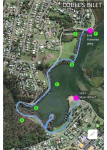
………..
Walk 5: Bastion Point
-37.5691 149.7621
eBird Hotspot: Bastion Point https://ebird.org/hotspot/L2552516
Best conditions: good at low tide
Take Betka Rd at roundabout and after Bowling Club turn left into Bastion Point Rd.
Accessibility: Stairs down to beach and beach walking thereafter. Not wheelchair friendly. At time of writing (14/2/21) the entrance (Y) is open, relatively deep and fast flowing. Wading should NOT be attempted. Also, if walking through the reedy marsh be alert for Tiger Snakes.
Distance: Variable but route shown is about 2.3 km.
Bird notes: The best site for waders and sea birds. It is hard to predict where the birds might be so scan all sandbars within the Inlet. The accessible sandbars should be scanned for small plovers (Red-capped & Hooded likely, perhaps early returning Double-banded). Large flocks of terns will mainly be Crested with 1 or 2 Caspian – make sure you scan for less common species (Common: Little; and Whiskered are most likely. Possibly an early returning White-fronted). Check out to sea for shearwaters; gannets and albatross especially if sea is rough.
The marshy area between the beach and Develings Inlet (X) can have Pipits and White-fronted Chat and there have been several recent records of Southern Emuwren.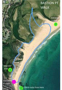
Drive & stop 5: Bastion Point
-37.5691 149.7621
eBird Hotspot: Bastion Point https://ebird.org/hotspot/L2552516
Drive all the way along Bastion Pt Rd to the carpark at the end. At low tide it is easy to check the rocks by walking down the stairs to point Z. There is very limited parking near the boat ramp: park at the top and use the stairs/ramp.
Accessibility: Wooden ramp to beach – not sure about slope. Disabled Parking at beach level.
Distance: Variable. If you park at top and walk to check area A its about 500m return.
Bird notes: This area is a hotspot for Eastern Reef Egret and Sooty Oystercatcher. Sea watch if rough weather.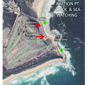
Walk 6: Mortimers Paddock
-37.5665 149.7569
eBird Hotspot: Mortimers Paddock Bushland Reserve https://ebird.org/hotspot/L12089924
Best conditions: anytime
Drive along Bastion Point Rd but turn into Mortimer St..
Accessibility: Flat dirt tracks. Tracks through centre could have fallen trees etc and narrow bridge across ditch on Rasmus Ave may need diversion to Betka Rd.
Distance: Route shown is ~1.5km
Bird notes: Bush and forest birds, often great sightings of Superb Lyrebirds. Glossy Black-Cockatoos have fed on Allocasuarinas here and Australian Figbird, Bassian Thrush & Olive Whistler possible.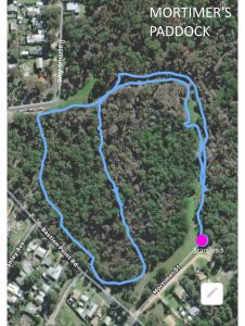
…………
Walk 7: Casuarina Track
-37.5589 149.7490
eBird Hotspot: Casuarina Walk https://ebird.org/hotspot/L2552528
Best conditions: anytime really
Take road towards Genoa from main central roundabout. Just past the end of the houses look on left for access point to get onto the verge and park near Walking Track signs.
Accessibility: Gravel bush track. Some steep pinches going into Davis Creek (X, Y). I am told by a wheelchair user it is navigable.
Distance: ~2km one way. Car shuffle possible.
Bird notes: Badly burnt area with luxuriant regrowth. Bush and forest birds. Powerful Owl seen here before fire and Whistling Kite nested in Spring 2020, possible area for Glossy Black-cockatoos.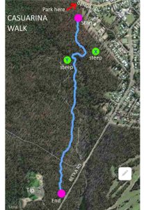
……………
Walk 8: Heathland Track
-37.5737 149.7481
eBird Hotspot: Heathland Walk. https://ebird.org/hotspot/L2552388 (When you get to Davis Beach car park could close and start second list as Betka River Mouth and Beach https://ebird.org/hotspot/L2552344.)
Best conditions: early morning & evening
Take Betka road out of town, down and cross Davis Creek. Near top of hill note railings for entrance to track on left. If parking space full park near entrance to Tip ~200 m further on.
Accessibility: Gravel bush track for about 1km is wheelchair accessible, stairs, beach and Chip Track are not.
Distance: ~4km for loop
Bird notes: Badly burnt area. First 500m mainly downhill through eucalypt woodland. Check creek for waterbirds. Then 100m of heathland, originally Allocasuarina paludosa (which is regenerating). Few birds in heath at present but worth checking. For beach and Chip Track sections see next Betka estuary site.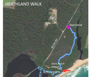
………………
Walk 9 : Betka Estuary
-37.5794 149.7468
eBird Hotspot: Betka River Mouth and Beach https://ebird.org/hotspot/L2552344
Best conditions: ? low tide
Take Betka road out of town, past Tip. On downhill just before Betka River, turn left signed to Davis Beach. Park neatly as the area is popular with surfers and fisherpersons.
Accessibility: Stairs and very soft sand. Not wheelchair accessible.
Distance: ~2km loop
Bird notes: The highlight is the Hooded Plovers at the mouth of the Betka River. Terns and gulls also at the mouth. Herons and ducks in the River. Check the cormorants on the roost for Pied and Black-faced Cormorants.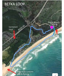
……………….
Walk 10: Gun Club & Airport
-37.5927 149.7264
eBird Hotspot: Gun Club Track https://ebird.org/hotspot/L4170489 or Mallacoota Airfield https://ebird.org/hotspot/L2552194
Best conditions: early evening
Take Betka road out of town, past Betka picnic area. Turn right on to dirt road to Airport. After sharp bend turn right towards FGA gun club.
Accessibility: Flat but bumpy dirt track. Probably OK for off-road wheelchair unless wet. Can be driven, but slippery when wet. Track at Y big potholes and at X a rutted bog: don’t go there.
Distance: ~4km loop
Bird notes: Very variable for birds. Sometimes not a bird observed . Heath can be good for Tawny-crowned Honeyeater and Ground Parrot (both reported since fire). Fence line, Aust Pipits, Jacky Winter and other insect eaters. Best site in area for Stubble Quail and Eurasian Skylark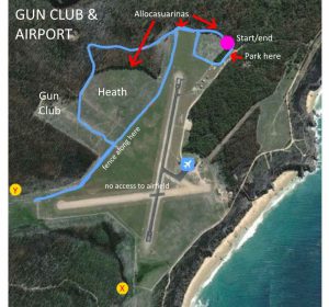
……………..
Drive & stop 11: Fishermans Point
-37.5988 149.7313
eBird Hotspot: Fishermans Point (Mallacoota) https://ebird.org/hotspot/L9767098
Best conditions: rough, windy
Head out of town past turnoff to airport. About 500m after start of dirt road on left marked to Geology Point. At end of track park and walk ~50 to lookout.
Accessibility: Wheelchair accessible, but rail on lookout may restrict view if seated.
Distance: 100 m
Bird notes: Has view to horizon for 125 degrees. In rough weather has potential for great sea-watching site if one knows seabirds (and has a telescope) .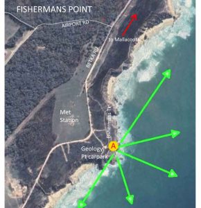
…………….
Walk 12: Shipwreck Creek
-37.6455 149.6985
eBird Hotspot: Croajingolong National Park – Shipwreck Creek https://ebird.org/hotspot/L2041682
Best conditions: very early morning, or maybe late evening
This site is ~15km out of town and the last 12 km are dirt road that can be badly potholed and corrugated if not recently graded. If strong winds recently high probability of fallen trees needing diversion off-road. However, some great birds have been seen here recently.
Go towards airport but stay on road marked to Shipwreck Creek. Road becomes dirt just after Airport turnoff. After a few km enter National Park. At the campground follow signs to Day Use Area. Track to beach is marked from dunny/notice board.
Accessibility: Steep rough track to beach, soft sand on beach, narrow rough track through heath, gate onto Betka Rd. Not wheelchair accessible,
Distance: ~4km loop walk
Bird notes: Main attraction is heathland. Incinerated in fire so heathland species greatly reduced. Ground Parrot & Southern Emuwren seen in area since fire (suggest early morning and evening for best chance), most sightings of Ground Parrot seem to be in heath to west towards Seal Creek. Tawny-crowned Honeyeater not seen since fire. Waders possible on beach, check ocean for seabirds.
………..
Drive & stop 13: Quarry Beach
-37.600814, 149.727730
eBird Hotspot: Quarry Beach https://ebird.org/hotspot/L3708050
Best conditions: probably low tide
Accessibility: Short run of stairs to beach.
Bird notes: Eastern Reef Egret sometimes seen here at low tide. Not much else to see here usually.
..
Notes from Martin Butterfield:
In the Key Maps above, the locations with an individual map are shown with a red number on a yellow background. A few other points shown with a blue number on a green background indicate spots at which a stationary checklist might be considered.
The maps are basically shown in a North-South order and there is no priority implied by the number. If other sites are added later they will be given the next available number. The commentary on the maps may assist in deciding which areas to visit.
The walk maps are generally derived from the tracking option offered by eBird and show the routes I have followed when birding in an area. There may well be opportunities for side tracks etc but hopefully there will be enough in these route maps to get you to the start of the track and back to where you started. I suggest you refer to a Map app on your phone in navigating to the start point or use this Google Map extract https://tinyurl.com/y6mbn2me.
I have given the decimal latitude and longitude coordinates (derived from Google Earth) of the start points to assist in navigating to those points. Note that this may or may not be the latitude or longitude of the locality as listed in eBird.
Note that the information shown for each map includes the name of the appropriate eBird Hotspot for the area. PLEASE record your birds against that hotspot rather than starting a new personal location.

